Urban Core
Project Overview
Urban Honolulu is transforming. In accordance with smart growth principles and transit oriented development, the city is concentrating future development within Honolulu’s urban growth boundary and in proximity to future rail stations. This densification will require a sustainable transportation network within the urban core, including transportation alternatives for those that can’t or don’t wish to use a car for all of their daily trips. With this transformation, Honolulu can realize the social, economic, and environmental benefits of becoming a more safe and walkable city.
Through its Complete Streets program, the City and County of Honolulu is committed to implementing complete streets solutions that improve safety, accessibility, and comfort for all users, encourage physical activity, and reflect community needs and character.
The Opportunity
Our projects in the Urban Core span diverse neighborhoods from Chinatown to Sheridan Tract. They includes some of the densest corridors on Oahu, home to key neighborhoods, business districts, schools, shopping centers, cultural institutions, government facilities, and medical facilities. In anticipation of the growing population of the Urban Core area of Honolulu, the City is studying safe and equitable improvements for Honolulu’s metropolitan center. A wide variety of outreach activities have been completed for the Urban Core Complete Streets projects, including eight “Sit Down Sessions”, four “Pop-ups”, six Walking and Biking Charrettes, and more than 30 meetings and presentations with community organizations, business associations, schools, major employers, landowners, elected officials, developers, and other stakeholders.
The project designs were informed by extensive community input gathered as a part of the Urban Core Complete Streets and Downtown Chinatown Complete Streets projects in 2017 and 2018. The outreach activities for these two projects included more than 24 community meetings, 72 stakeholder meetings, and various other outreach platforms, collectively gathering more than 1,600 public comments. Complete Streets are:
- Safe and convenient for people of all ages and abilities
- Accommodating to all modes, including foot, bicycle, transit, and automobile
- Integrated with the community’s vision and sense of place
- Supportive of community health and transportation equity
Current and Upcoming Projects
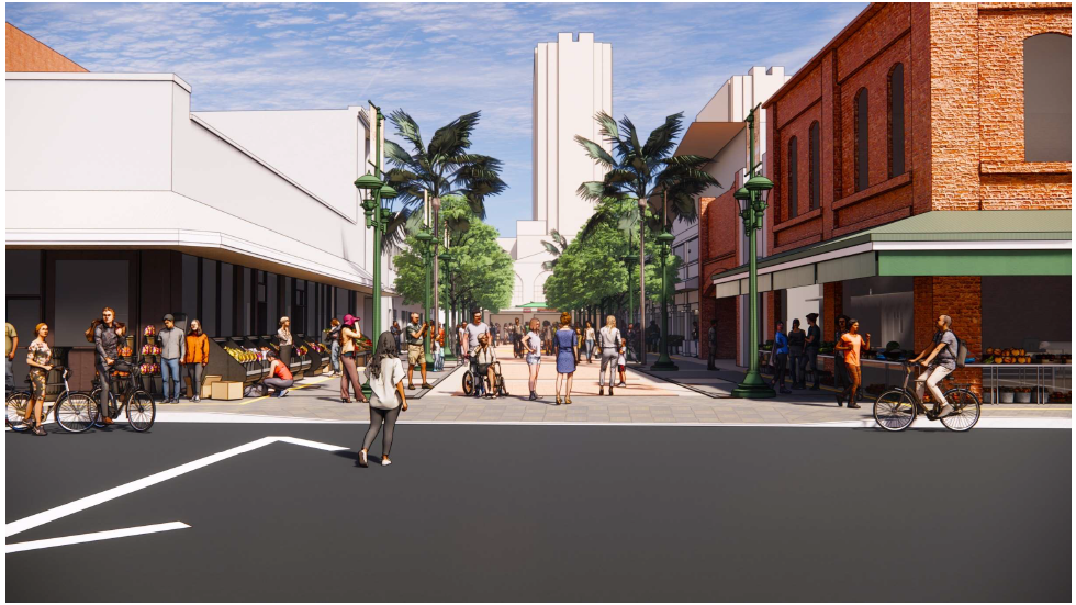
Kekaulike Mall and Street Improvements
Kekaulike Mall and Kekaulike Street are critical cultural, economic and transportation facilities in the heart of our city that connect our island’s busiest transit corridors, including King Street, Hotel Street, and eventually the rail system. These improvement projects are intended to prioritize safe and comfortable pedestrian travel in Chinatown.
Reconstruction of Kekaulike Mall began in spring 2023. Project boundaries are from Hotel Street to King Street. The project will improve drainage, pavement, lighting, landscaping, and loading areas. It will incorporate landscaping and wayfinding to support economic activity. Access to businesses will be maintained during construction. Construction hours will be Monday through Friday from 9:00 AM – 5:00 PM, with no weekend or holiday work. Please contact the Project Hotline at (808) 979-1291 with any questions or concerns.

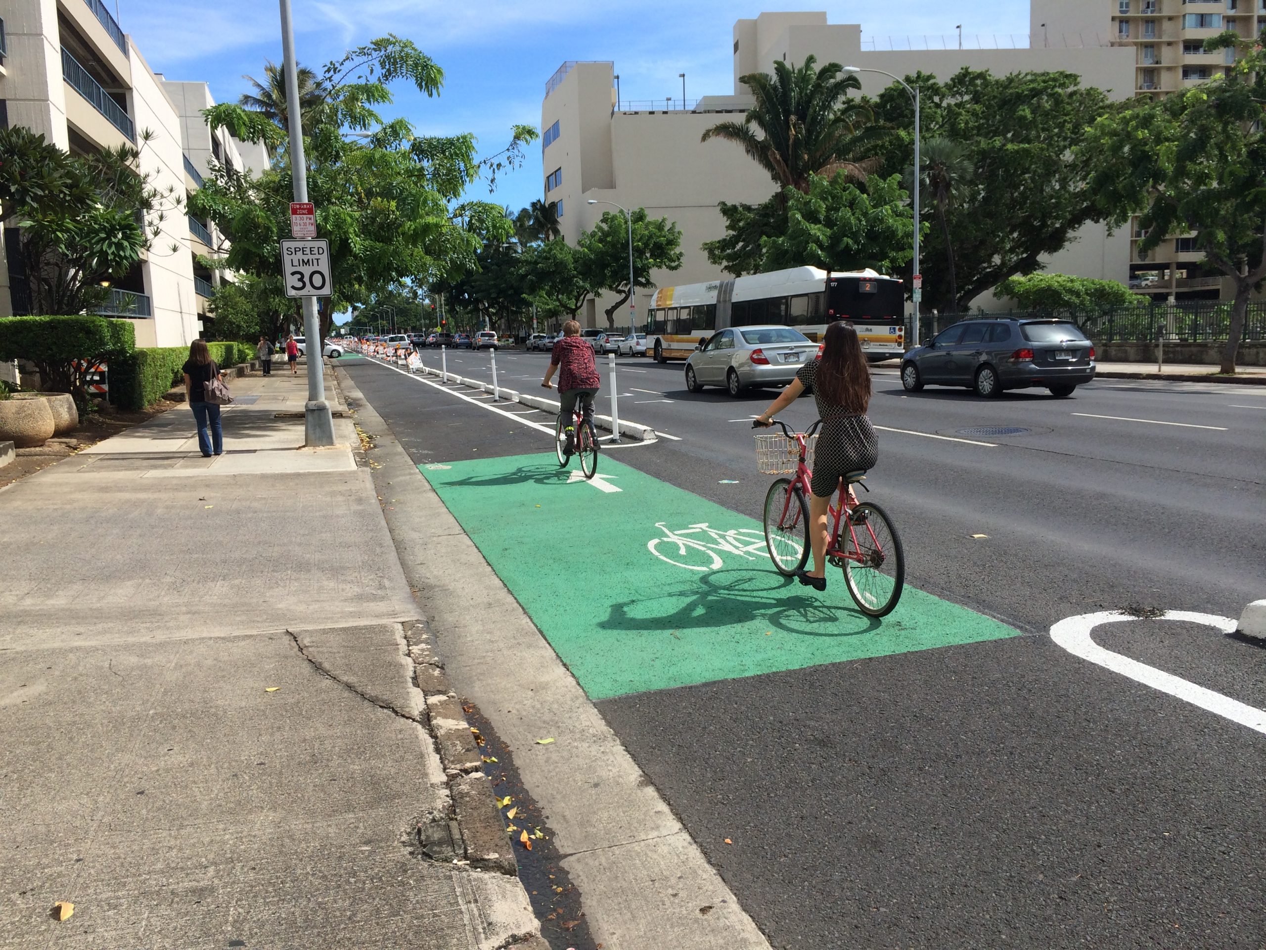
Urban Core Bikeway Improvements
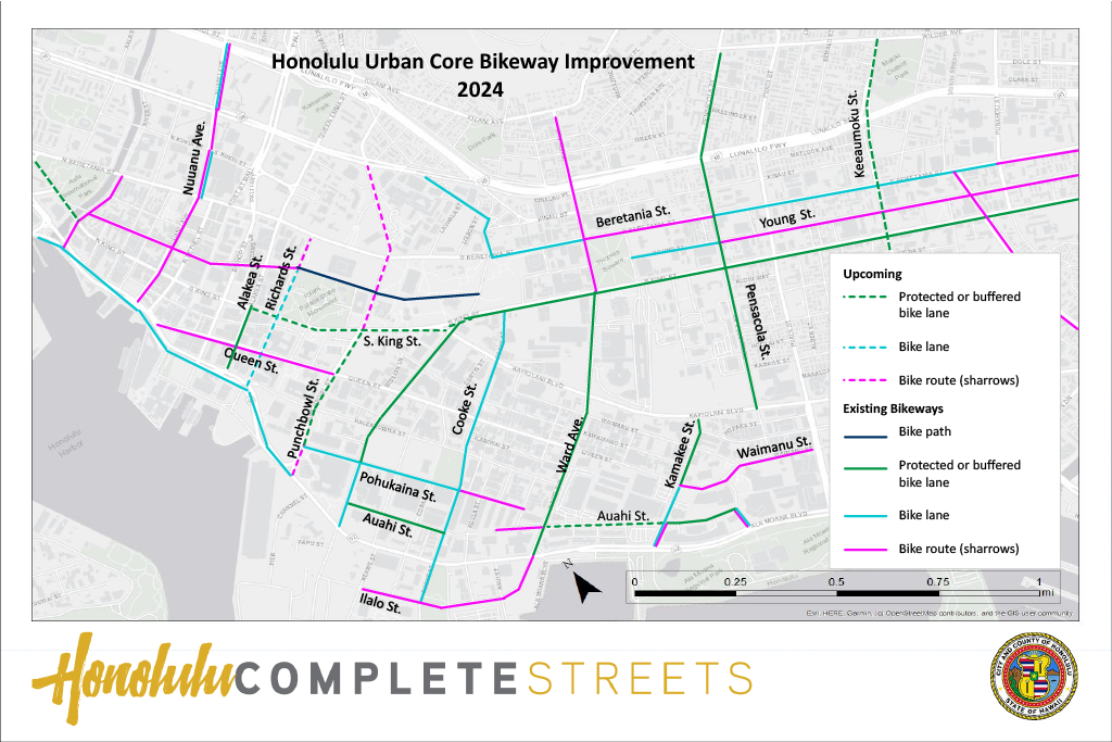
New bikeway projects will be constructed in the Downtown, Chinatown, and Ala Moana-Kakaʻako areas, with many in conjunction with road repaving projects. Click the image to see the most recently updated Bikeways Plotter Map.
Downtown
- South King Street: Extension of the existing two-way protected bike lane along the mauka side of the road, between Alapaʻi Street and Alakea Street
- Punchbowl Street: Bicycle facilities between Vineyard Boulevard and Ala Moana Boulevard include:
- Sharrows (mauka-bound) between South King Street and Vineyard Boulevard
- One-way protected bike lane (makai-bound) between Pohukaina Street and South King Street
- Sharrows (makai-bound) from Vineyard Boulevard to South King Street and from Pohukaina Street to Ala Moana Boulevard
- Richards Street:
- One-way bike lane (makai-bound) from Halekauwila Street to South Hotel Street
- Sharrows (makai-bound) from South Hotel Street to South Beretania Street
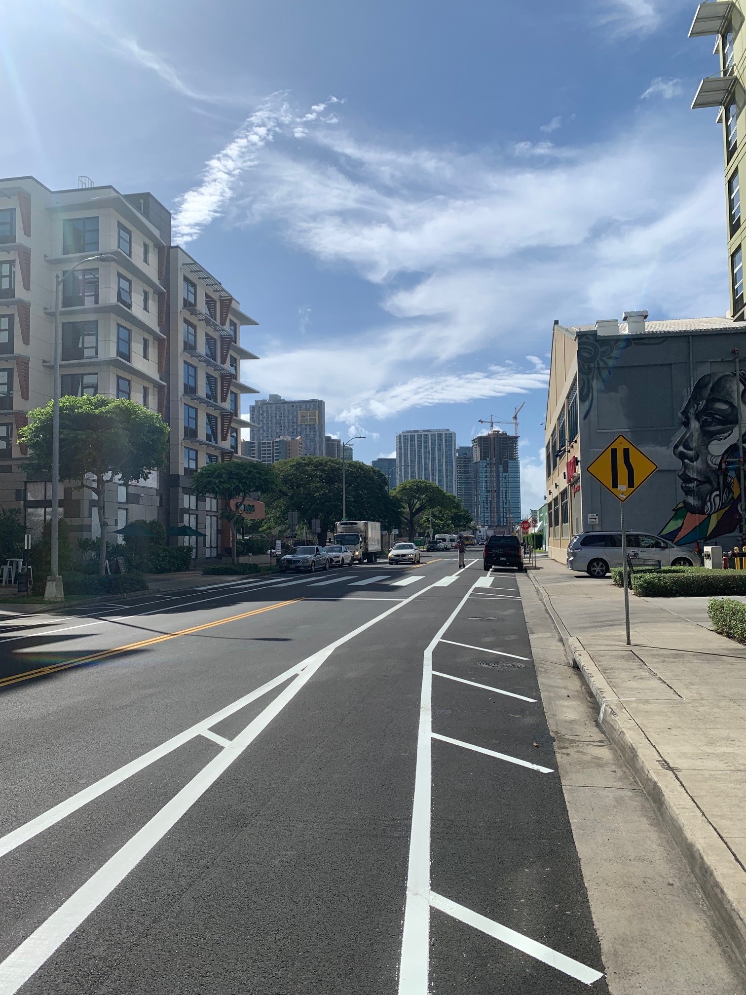
Ala Moana-Kakaʻako
Construction of bikeways on Kamakeʻe Street, Auahi Street, Cooke Street, Pohukaina Street, Queen Street, and Ilalo Street is in progress.
- Kamakeʻe Street: One-way protected bike lane from Queen Street to Kapiolani Boulevard
- Auahi Street: Buffered bike lanes from South Street to Cooke Street
- Cooke Street: Bike lanes from South King Street to Ilalo Street
- Pohukaina Street:
- Bike lanes from Punchbowl Street to Cooke Street
- Sharrows from Cooke Street to Kamani Street
- Queen Street:
- One-way bike lanes (mauka-bound) from Ala Moana Boulevard to Auahi Street
- Sharrows (makai-bound) from Auahi Street to Ala Moana Boulevard
- Sharrows from Fort Street Mall to Punchbowl Street
- Ilalo Street: Sharrows installed from Keawe Street to Ala Moana Boulevard
Keʻeaumoku Street
Keʻeaumoku Street provides important mauka-makai connections between Makiki, Ala Moana, and major east-west corridors. The study area encompasses Keʻeaumoku Street from Kapiʻolani Boulevard to Wilder Avenue. The project team has collected and analyzed data, studied existing transportation patterns, and worked closely with community members and stakeholders to identify design solutions that balance the needs of all those who use the street. Keʻeaumoku Street is programmed for major roadway rehabilitation, and this road-paving project provides a cost-effective opportunity to implement appropriate safety improvements. Safety improvements being considered include, but are not limited to, improved pedestrian crossings, protected bicycle lanes, and traffic calming.
The purpose of this projects is to transform Keʻeaumoku Street into a “Complete Street,” with a street design that balances the needs of people of all ages and abilities whether they are walking, using a wheelchair, on a bike, riding transit, or in a car. Keʻeaumoku Street is programmed for major roadway rehabilitation, and this road-paving project provides a cost-effective opportunity to implement appropriate safety improvements.
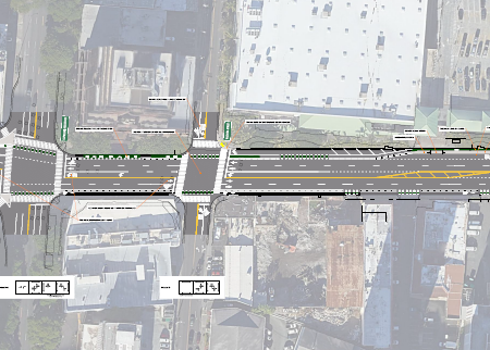
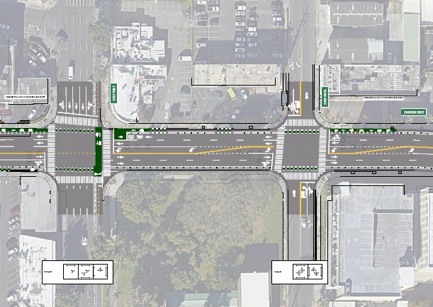
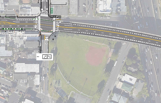
Plans
Click thumbnails to view and/or download plans.
If you require an auxiliary aid/service, other accommodation due to a disability, or an interpreter for a language other than English, to read these plans, please call Daniel Alexander at (808) 768-6652 or email completestreets@honolulu.gov.
Community Meetings
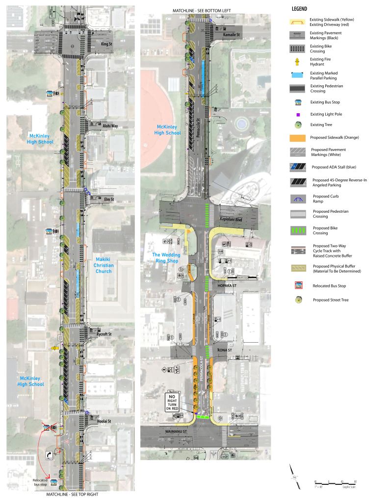
Lower Pensacola Street Pedestrian/Bikeway Improvements
In November 2023, The Hawaiʻi State Department of Transportation (HDOT), in partnership with DTS, installed four new raised crosswalks fronting McKinley High School on Pensacola Street at Elm, Rycroft, Hoʻolaʻi, and Kamaile Streets. IIn an effort to increase safety, reduce motor vehicle speeds, and prevent collisions, the raised crosswalks are an interim treatment to improve safety until the future implementation of the full Complete Streets plan for the corridor.
The City and County of Honolulu is planning to implement improvements along Pensacola Street between Waimanu Street and South King Street. This would include improvements to pedestrian crossings, complete the missing sidewalks between Waimanu Street and Kapiʻolani Boulevard, and extending the two-way protected bikeway to Waimanu Street. These improvements are proposed to provide safer and more direct connections to and from Kakaʻako, Ala Moana Shopping Center, and Ala Moana Regional Park for both pedestrians and bicyclists.
The project area encompasses Pensacola Street from Waimanu Street to South King Street, and the project area is broken into two segments:
Segment 1, from Waimanu Street to Kapiʻolani Boulevard: Improvements include incorporating missing sidewalks, reconfiguring on-street parking, extending the two-way protected bikeway, and adding crosswalks and pedestrian signals on the Diamond Head side of the intersection with Kapiʻolani Boulevard and Waimanu Street.
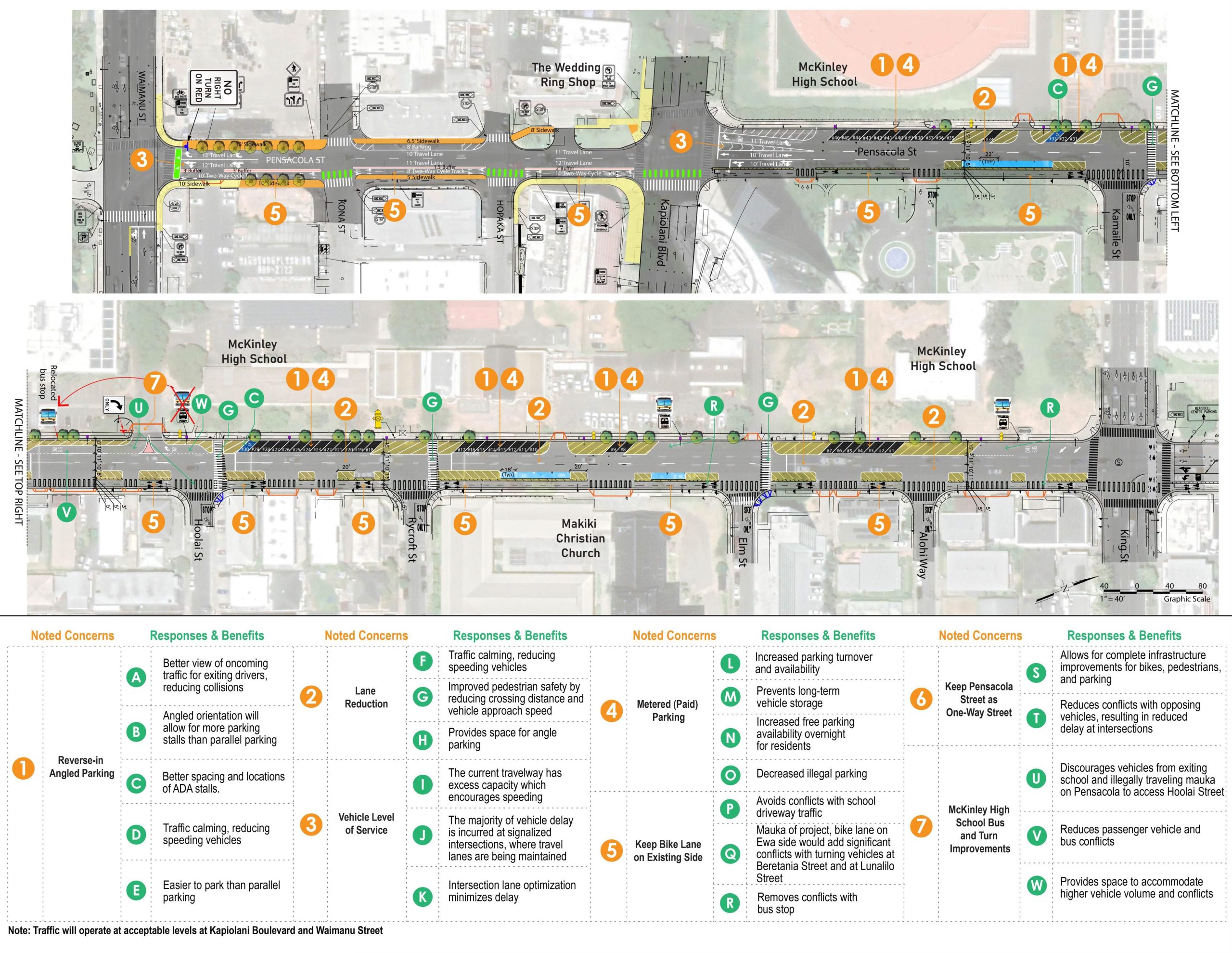
Segment 2, from Kapiʻolani Boulevard to South King Street: Improvements include pedestrian crossing safety improvements, curb extensions, reverse-in angle parking, and a lane reconfiguration to address speeding issues while maintaining capacity.
View a Reverse-In Angle Parking How-To Video on YouTube HERE.
For questions and/or comments on the Lower Pensacola Street Pedestrian and Bikeway Improvements project, please contact Daniel Alexander, Project Manager, Department of Transportation Services at (808) 768-6652, or via email at completestreets@honolulu.gov .
Community Meetings
Interactive Map
Click on the interactive map to view community comments about issues residents encountered, or ideas community members have to make the area safer and more accessible for all.